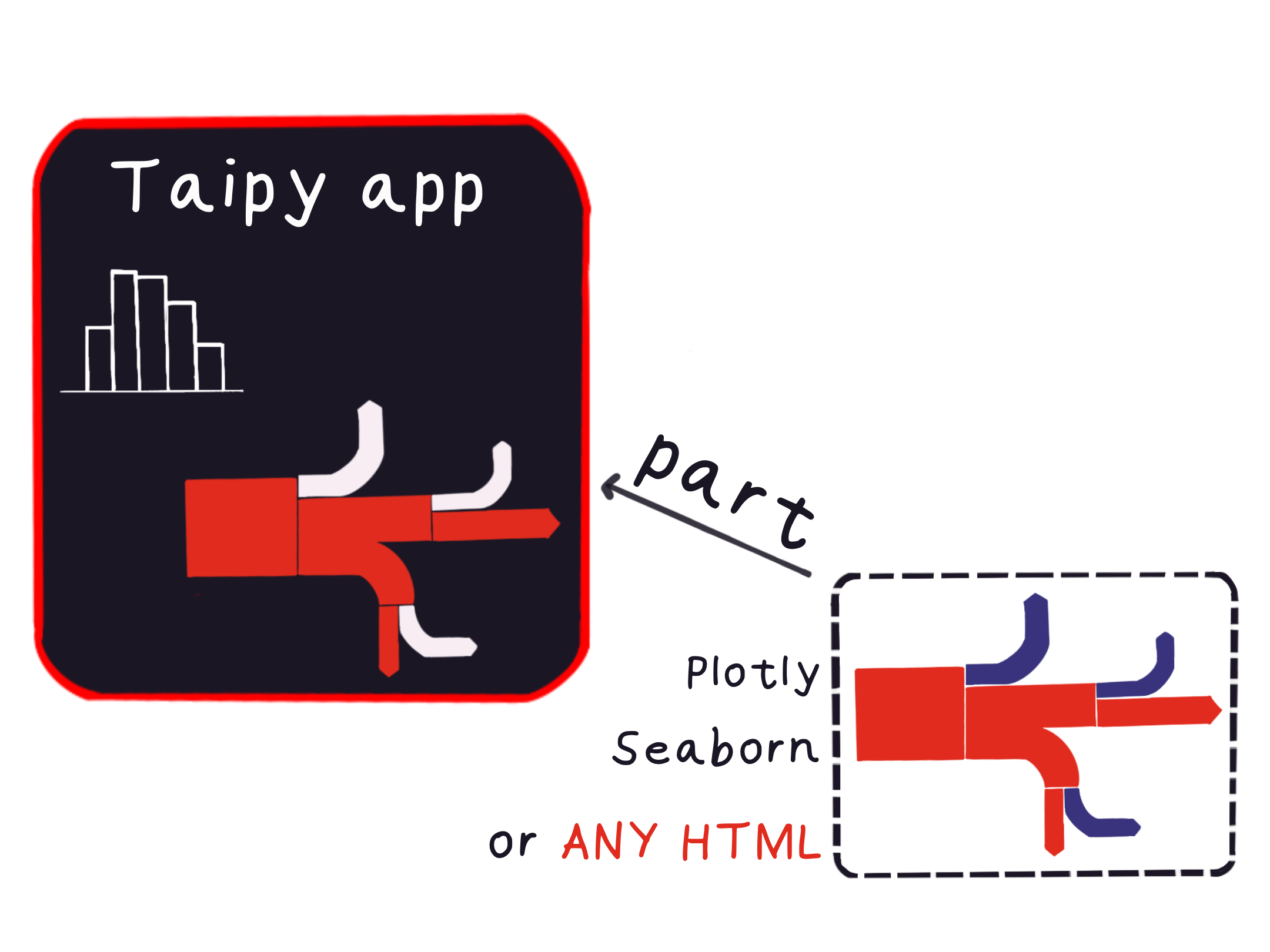
Integrate Third-Party Components
In the world of web development, it's often necessary to integrate third-party components into your applications. These components could range from interactive visualizations to videos or other web pages. This article will demonstrate how to effectively include external resources, focusing on embedding a Folium Map into a web application.
Example: Embedding a Folium Map
Let's explore a practical example of integrating a Folium Map into a web application. Folium is a powerful visualization tool for representing various maps, finding applications in energy studies, cost analysis, and network analysis.
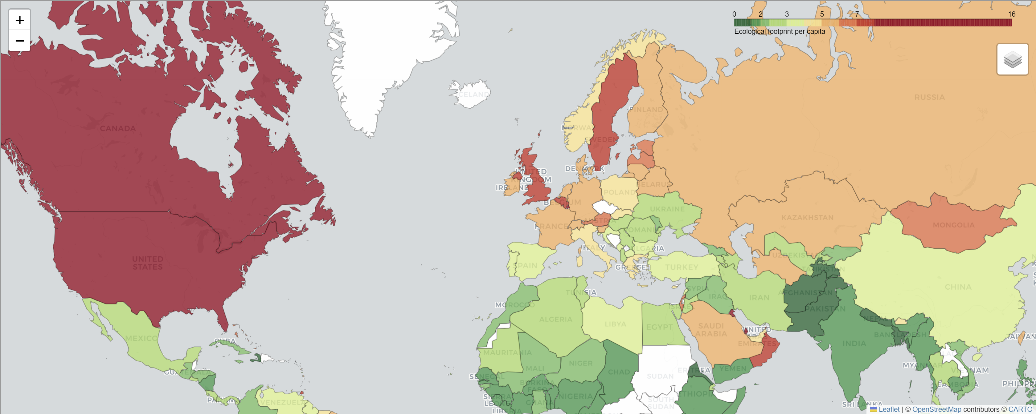
In our scenario, we have a Python application that processes recruitment data, performs analysis, and generates a Folium Map using Folium, a Python library for creating interactive maps.
Here's a code snippet creating a Folium object:
import folium
import pandas as pd

eco_footprints = pd.read_csv("footprint.csv")
max_eco_footprint = eco_footprints["Ecological footprint"].max()
political_countries_url = (
    "http://geojson.xyz/naturalearth-3.3.0/ne_50m_admin_0_countries.geojson"
)

def folium_map():
    # Create the folium map
    map = folium.Map(location=(30, 10), zoom_start=3, tiles="cartodb positron")
    folium.Choropleth(
        geo_data=political_countries_url,
        data=eco_footprints,
        columns=("Country/region", "Ecological footprint"),
        key_on="feature.properties.name",
        bins=(0, 1, 1.5, 2, 3, 4, 5, 6, 7, 8, max_eco_footprint),
        fill_color="RdYlGn_r",
        fill_opacity=0.8,
        line_opacity=0.3,
        nan_fill_color="white",
        legend_name="Ecological footprint per capita",
        name="Countries by ecological footprint per capita",
    ).add_to(map)
    folium.LayerControl().add_to(map)

    return map
Integrating the Folium Map
To integrate this map object into our web application, we need to create the HTML version of this object. Here is the code that achieves this:
import tempfile

def expose_folium(map):
    with tempfile.NamedTemporaryFile(delete=False, suffix=".html") as temp_file:
        map.save(temp_file.name)
        with open(temp_file.name, "rb") as f:
            return f.read()
In this code, the function expose_folium() converts a Folium object (map) to HTML, a mandatory step in integrating any third-party component into your application.
We now proceed to register a function for the object type we want to display. The code below
means that when Taipy encounters a Map type in the content property, it will use the
expose_folium function to convert it to HTML and display it on the page.
from folium.folium import Map

Gui.register_content_provider(Map, expose_folium)
Finally, we can embed the Folium Map using the following the part component:
<|part|content={folium_map()}|>
You can adjust the layout by changing its width and height. This element seamlessly integrates the Folium Map into your web app.
Conclusion
Incorporating third-party components into your web applications is a powerful technique to enhance user experience significantly. You can achieve this by converting external content into HTML and seamlessly integrating it into your web app.
This article demonstrated how to embed a Folium Map using this method. This approach also ensures that the integrated content doesn't interfere with your page and provides a secure user experience.
Entire Code
import tempfile
import folium
from folium.folium import Map
import pandas as pd
from taipy.gui import Gui


def expose_folium(fol_map: Map):
    with tempfile.NamedTemporaryFile(delete=False, suffix=".html") as temp_file:
        fol_map.save(temp_file.name)
        with open(temp_file.name, "rb") as f:
            return f.read()


eco_footprints = pd.read_csv("footprint.csv")
max_eco_footprint = eco_footprints["Ecological footprint"].max()
political_countries_url = (
    "http://geojson.xyz/naturalearth-3.3.0/ne_50m_admin_0_countries.geojson"
)


def folium_map():
    # Create the folium map
    fol_map = folium.Map(location=(30, 10), zoom_start=3, tiles="cartodb positron")
    folium.Choropleth(
        geo_data=political_countries_url,
        data=eco_footprints,
        columns=("Country/region", "Ecological footprint"),
        key_on="feature.properties.name",
        bins=(0, 1, 1.5, 2, 3, 4, 5, 6, 7, 8, max_eco_footprint),
        fill_color="RdYlGn_r",
        fill_opacity=0.8,
        line_opacity=0.3,
        nan_fill_color="white",
        legend_name="Ecological footprint per capita",
        name="Countries by ecological footprint per capita",
    ).add_to(fol_map)
    folium.LayerControl().add_to(fol_map)

    return fol_map


Gui.register_content_provider(Map, expose_folium)
Gui("<|part|content={folium_map()}|height=600px|>").run()